⛰️ Hidden Haven: A Guide to the Waterfall in Brian Head's Burn Scar
 |
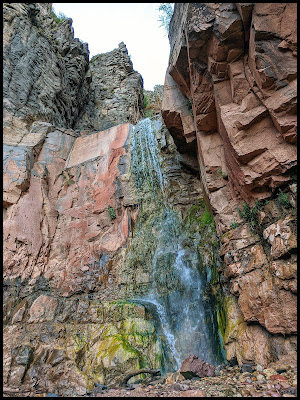
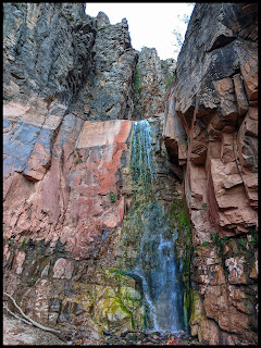
| The incredible contrast of red rock, black cliffs, and green moss at Hidden Haven. |
After the breathtaking views of Cedar Breaks, you're often left feeling inspired and energized, wanting just one more adventure for the day. Tucked away near Brian Head is the perfect answer: Hidden Haven. This short trail leads to one of the most uniquely colorful waterfalls I’ve ever seen. But this is a hike with a story—it’s a place of incredible beauty born from the aftermath of a massive wildfire. The journey is a constant reminder of nature's power, both to destroy and to create stunning resilience. It's a gem I've returned to multiple times, and its beauty never fails to amaze me.
⚠️ Know Before You Go: Burn Scar & Flash Flood Risk
This is extremely important. The trail to Hidden Haven is in the burn scar of the 2017 Brian Head fire. The landscape is beautiful but vulnerable.
- ♦️ CHECK THE FORECAST: DO NOT attempt this hike if there is any rain in the forecast for the surrounding area. The burn scar creates a high risk of flash floods and debris flows (falling trees, mud, rocks) that can come down the canyon with little warning.
- ♦️ CONSTANT CHANGE: The trail conditions can change dramatically from year to year as new logs and debris wash over the falls and down the creek bed. Be prepared for an obstacle course.
- ♦️ STAY AWARE: If the weather looks threatening, turn around immediately. Your safety is more important than any photo.
🗺️ Adventure at a Glance
- 🏞️ Location: Near Parowan & Brian Head, Utah, just off Highway 143.
- 🥾 Hike: Hidden Haven Waterfall Trail
- 📏 Distance: Approx. 1.4 miles round trip.
- 📈 Elevation Gain: About 300 feet.
- ⏱️ Time to Complete: 1-1.5 hours
- ⭐ Shauna's Rating: 💎💎💎💎💎 (5 out of 5 Diamonds)
A COLLECTION OF FAVORITE WATERFALLS
This VR Getaway is a journey to some of my favorite waterfalls, and the vibrant, colorful Hidden Haven makes a star appearance at the 2:40 mark. See for yourself why this spot is so special!
🥾 The Journey: A Colorful Oasis in a Scarred Canyon
A Trail of Constant Change
The first thing you notice on the Hidden Haven trail are the warning signs. They make it clear this area was heavily impacted by the Brian Head fire. Because the vegetation that once held the soil is gone, the canyon is in a constant state of flux. Each time I've visited, the path has been slightly different, with new logjams and debris fields to navigate. It's a humbling reminder of the area's history, but the local trail crews do a wonderful job of keeping the path to the waterfall accessible.
The Reward: A Kaleidoscope of Color
After a short and adventurous hike, you're rewarded with the waterfall, and it is absolutely breathtaking. The colors are what make it so unique. The water cascades over tall cliffs streaked with bright red and deep black rock, while a vibrant green moss thrives in the constant spray. The contrast is simply stunning. It’s a photographer’s dream and a perfect spot to just sit and soak in the beauty. Despite the obstacles, I've been drawn back 3 or 4 times—it's just that incredible.
 |
| Soaking in the beauty of the falls. |
💡 Pro-Tips & Trail Guide
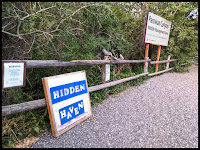
- ♦️ Finding the Trailhead: There are a few access points, but the main one is an easy-to-miss pullout on the west side of Highway 143, south of Parowan and north of Brian Head. Look for the "Hidden Haven" sign.
- ♦️ The Fork in the Trail: The trail is Y-shaped. The path to the right (heading upstream) leads to the waterfall. I haven't yet explored the path to the left, but I believe it leads to a scenic viewpoint.
- ♦️ Perfect Add-On Hike: This is a fantastic, short hike to do after a day exploring Cedar Breaks National Monument. The trailhead is just a short drive away.
- ♦️ Other Nearby Gems: This area is packed with amazing sights! Don't miss Cascade Falls (where water shoots out of a lava tube!) and the incredible rock formations of Noah's Ark / Vermillion Castle.
⭐ Final Thoughts
Hidden Haven is a powerful lesson in contrasts—a place where the scars of a wildfire have given way to a vibrant, colorful, and resilient oasis. It’s a short hike with a massive reward, but one that demands respect for the power of nature. As long as the skies are clear, I can't recommend this beautiful trail enough. You won’t regret seeing this gem for yourself.
Sending Love and Positive Vibes,
Shauna from VRGetaway
____
Oculus Quest Headset Links
This Roadtripping to Sedona's Fairyland & Grand Canyon also spotlights thsi trail at the begining.
How I found the Hidden Haven Waterfall.
 |
| Cool bench leg made out of a tree stump. Fabulous! I love the root feet! |
Information about Hidden Haven Trail
- About 3.5 miles south of Salt Lake City.
- Trail is Medium Difficulty because of the bouldering and obstacles.
- Trail is appropriate for kids 10 and up.
- Trail is about 1.4 miles round trip for the waterfall. If you go to the viewpoint that I bet is quite the Haven, I think your total would be about 2.5 miles.
- Trail has cute campsites, picnic tables, and benches along the trail.
- Trail has a split, so it is Y shaped. The one side goes to the waterfall, and I am sad to say I don't know where they other side goes. Quite sure it is a spot with spectacular views of the cliffs from where it ends up.
- The problem with this trail is that because of the fire in Bryan Head a few years ago, it has left lots of dead trees and caused mudslides in this area. As a result, the stream here has had a beating lately and is an area you might want to avoid if there is a rainstorm coming, for you never know what might wash downstream. That being said, when you get into the river it is similar to hiking Kanarraville where there is some bouldering, but it is not that hard and is a fun challenge to build your hiking skills.
- There are actually 3 trailheads to this trail. Two are just on the main road up to Bryan head. The other trail is off the new road just off the 143 that travels along Benson Creek. It will be on your right soon after you turn onto this new road. This would make this trail even shorter.
Cool hikes in the area that you should do while you are in the area.
Cascade Falls
 |
| Cascade Falls and Sunrays |
 |
| Cascade Falls- by Cedar City |


.png)


.png)


0 Comments
I would love to hear your thoughts about this area or this post. Feel free to leave a comment here.